Development Cooperation
For many years we have conducted various projects in the field of development cooperation in close collaboration with different international research centres, universities, organisations and companies.
Scope of services
- Support in introducing geographic information systems in administration and institutions
- Capacity Building, schoolings in GIS, GPS, remote sensing, databases in different languages
- Advice and guidance for projects, optimization of workflows
- Project monitoring, for example with geoSYS Mobile
- Preparation of GIS-related reports and studies
- Data acquisition with GPS and drones, evaluation of remotely sensed data
- Conduction of GIS analyses and creation of maps
- Application development, development of software solutions for desktop, mobile and web systems
- Vast consulting experience in environment monitoring, tourism, hydrology, climate, forest and wood management, rating of biosphere reserves
Project Examples
Development of a Tracking App
For the GRAS Global Risk Assessment Services GmbH, geoSYS developed a mobile app for Android and an online dashboard to manage, filter and visualize the data collected by the app. The app’s main purpose is the scanning of QR codes to register production flows and audit sustainable fruit cultivation. The online dashboard offers the possibility to generate QR codes. The generated QR codes create unique IDs for delivers/pickup tours, farmers, carriers and mill workers. The QR codes are saved in a central database and are subsequently distributed to anyone who is involved in the transportation process. This logic makes it possible for the smartphone app to register specific pieces of information at different locations by still attributing them to the same transportation route.
Client / Project Partners
Meo Carbon Solutions Gmb, GRAS Global Risk Assessment Services GmbH
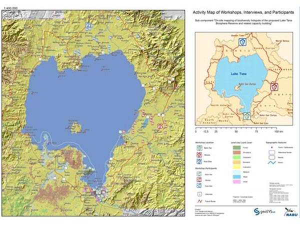
Mapping and Cartography of Biodiversity Hotspots
Data collection, processing and cartography of biodiversity hotpots in the Tana biosphere preserve. The maps were part of an extensive report covering the state and offering suggestions about the topics of deforestation and ecosystem performance. The project’s infrastructure was Esri-based, including the use of ArcGIS to process data and the use of ArcGIS for Server to publish spatial web services.
Client / Project Partners
NABU International
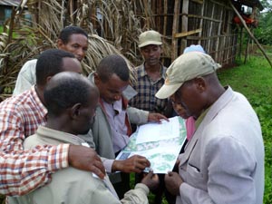
UNESCO Kafa Biosphere Reserve, Ethiopia
In June 2010, the Biosphere Reserve situated in the southwest highlands of Ethiopia, was officially recognised by UNESCO. The zoning of the biosphere reserve was conducted under patronage of NABU e.V. and with the expertise of geoSYS. The main aim of the project is the protection of the afro-montane cloud forest in the Kafa zone. An emphasis on sustainable forestry management aims to reduce deforestation and the associated greenhouse gas emissions. Protection of the forest also safeguards a considerable carbon storage capacity, and the livelihoods of local residents with respect to the different forestry functions is preserved. The main areas of responsibility of geoSYS in this project include:
- Analysis of forest coverage („Forest Benchmark Map“, „Change Detection“) with the aid of remote sensing techniques and GIS analyses
- Analysis of the conflict potential between stakeholders and BR. Conducted with the aid of empirical case studies, workshops and cooperation with local partners
- Identification of suitable afforestation sites and „action sites“ that are interesting in terms of balancing the carbon cycle. In this respect, remote sensing techniques were used as well as in situ analyses.
- Training of the people involved in GIS and GPS data capture
- Preparation of a webmapping application for the project
Client / Project Partners
UNESCO, FAO, Naturschutzbund e.V., GTZ, GEO schützt den Regenwald e.V., Hochschule für nachhaltige Entwicklung Eberswalde
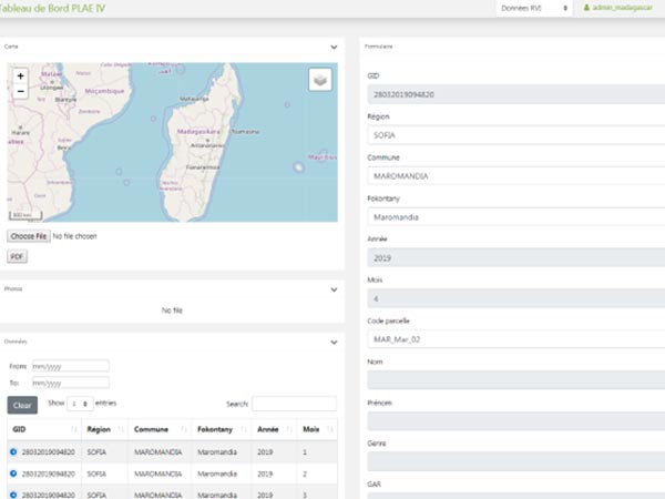
PLAE IV, Madagascar - GIS-based identification of intervention zones and impact monitoring of reforestation and erosion safety measures
geoSYS engaged in the development of a forest and risk management system. A smartphone application and a dashboard were developed to let users record, edit and upload spatial and attribute data, as well as visualize existing data. The smartphone application functions offline and data is locally stored in a SQLite / SpatiaLite database that synchronizes with a server-side PostgreSQL / PostGIS database once internet connection is obtained. Once uploaded the data can be visualized, filtered and queries in an online dashboard.
The GIS and analysis part of the project includes remote sensing analysis and classification of selected areas, by paying special attention to forest cover (extensive deforestation) and the directly linked erosion.
The possibilities of data collection, supported by the GIS and remote sensing analyses, make up a powerful monitoring system to identify risks and danger for local populations and natural areas as well as to support reforestation planning. Different groups of users of the mobile application and the dashboard were trained in Antananarivo and surrounding regions, introducing them to real-world scenarios and demonstrating offline functionality and multi-language support.
Client / Project Partners
GFA Consulting Group GmbH, KfW
Aid, Minds, Hearts: A Longitudinal Study of Governance Interventions in Afghanistan
Using our data, we will be able to test whether the intervention meets its objectives. Drawing on additional qualitative data will allow us to move beyond establishing or denying causality, and to explore the causal mechanisms in greater depth, i.e. to understand the contexts in which the co-variation occurs, and the likely consequences that it has.
Client / Project Partners
Freie Universität Berlin, ISAF
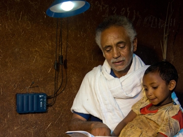
Mobile Monitoring for Solar Home Systems, Ethiopia
In the context of the Energising Development Initiative (EnDev), commissioned by atmosfair und Fosera GmbH, geoSYS is involved in the development of a mobile monitoring system for data collection and management of solar systems.
In cooperation with Fosera Manufacturing from Bahir Dar atmosfair aims to spread solar systems as an alternative to kerosene lamps. To achieve this goal qualitatively high yet affordable solar systems are installed. A total of 20,000 solar systems are planned to be sold in rural areas in Ethiopia. To ensure the long term success of the project a smartphone-based monitoring to keep track of the solar systems is being developed by geoSYS. The system possible to analyze the spatial distribution of the Solar Home Systems and thereby quantify the project’s success.
- Development of a central monitoring-database on a server that is accessible through the internet
- Development of a monitoring app, with offline capability, to track the solar systems on site
- Implementation of an automated replication of datasets that were acquired offline to a central database, assuming a stable internet connection
- Development of a web-based dashboard to visualize monitoring data in interactive maps or tables
- Deployment of automated database exports to be used in various software programs
Client / Project Partners
atmosfair, Fosera Äthiopien, Fosera Deutschland, Deutsche Gesellschaft für Internationale Zusammenarbeit (GIZ)