Environment & Climate
Environment and climate are central themes reported on a daily basis in the media - newspapers, television news or online portals. Since founding this company we have worked on both national and international projects contributing to the protection of people and the environment by the use of GIS and remote sensing methods. Risk analysis, and the preparation of expert reports, especially those relating to climate change and the links to resulting environmental changes and natural disasters, form the basis of our work. In cooperation with scientific institutions and technical partners, we predominantly work on international cooperation projects. A detailed overview of the various projects and clients is included in our references section. For further information please do not hesitate to contact us.
Scope of services
- Use of GIS and remote sensing methods in the analysis of environmental topics (environmental protection, monitoring etc.)
- Vulnerability analyses on environmental and climate change
- Preparation of terrain models, geomorphological and hydrological analyses using current models and scenarios, 3D and 4D simulations and modeling
- Analysis of natural hazards, risk management and preparation of expert reports
- Preparation of topographic and thematic maps including data capture, mapping and monitoring
- Capacity building and international consulting
- Web-based visualisation of risk management, implementation of web portals (e.g. Ushahidi etc.)
- Participation in research projects with respect to geomorphological, hydrological and climate issues
Project Examples
Prebetatest and Betatest for the Climate Information System ci:grasp
ci:grasp, climateimpacts: global and regional adaptation support platform is a web-based climate information service of GIZ and the Potsdam Institut für Klimafolgenforschung, who aim to support decision makers and scientists in developing countries with the planning and implementation of suitable adjustment strategies to climate change. Prior to the start of the platform comprehensive tests, such as a pre-Betatest and a Betatest, were carried out. The Betatest comprised of the development of an online-questionnaire and the supervision of approx. 200 Betatests conducted worldwide.
Client / Project Partners
GIZ GmbH, Potsdam-Institut für Klimafolgenforschung
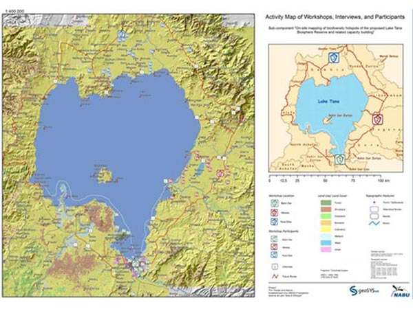
Mapping and Cartography of Biodiversity Hotspots
Data collection, processing and cartography of biodiversity hotpots in the Tana biosphere preserve. The maps were part of an extensive report covering the state and offering suggestions about the topics of deforestation and ecosystem performance. The project’s infrastructure was Esri-based, including the use of ArcGIS to process data and the use of ArcGIS for Server to publish spatial web services.
Client / Project Partners
NABU International
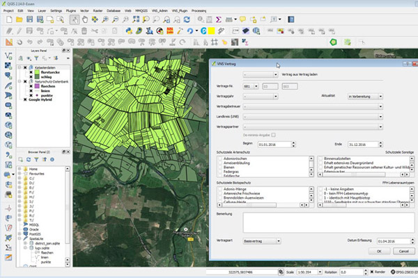
QGIS Plugin for conservation management agreements for the Landesamt für Umwelt in Brandenburg
geoSYS has created a QGIS plugin for the Landesamt für Umwelt, Gesundheit und Verbraucherschutz Brandenburg. The plugin's purpose is the administration of conservation management agreements. This new solution replaces the former PEP-GIS, which had to be used in ArcView.
The following points portray major components or functions of the plugin:
- Entry and maintainance of conservation management agreements
- Local saving of data and geometries in a SpatiaLite database
- Merging and synchronization of multiple local databases
- Automated and customizable SQL queries
- Import and export of central databases to local databases
- Automated creation of PDF documents, based on data entry
- 1-click creation of maps with point/line/polygon geometries
Client / Project Partners
Landesamt für Umwelt (Brandenburg)
UNESCO Kafa Biosphere Reserve, Ethiopia
In June 2010, the Biosphere Reserve situated in the southwest highlands of Ethiopia, was officially recognised by UNESCO. The zoning of the biosphere reserve was conducted under patronage of NABU e.V. and with the expertise of geoSYS. The main aim of the project is the protection of the afro-montane cloud forest in the Kafa zone. An emphasis on sustainable forestry management aims to reduce deforestation and the associated greenhouse gas emissions. Protection of the forest also safeguards a considerable carbon storage capacity, and the livelihoods of local residents with respect to the different forestry functions is preserved. The main areas of responsibility of geoSYS in this project include:
- Analysis of forest coverage („Forest Benchmark Map“, „Change Detection“) with the aid of remote sensing techniques and GIS analyses
- Analysis of the conflict potential between stakeholders and BR. Conducted with the aid of empirical case studies, workshops and cooperation with local partners
- Identification of suitable afforestation sites and „action sites“ that are interesting in terms of balancing the carbon cycle. In this respect, remote sensing techniques were used as well as in situ analyses.
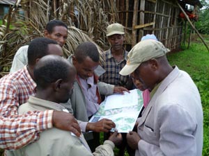
- Training of the people involved in GIS and GPS data capture
- Preparation of a webmapping application for the project
Client / Project Partners
UNESCO, FAO, Naturschutzbund e.V., GTZ, GEO schützt den Regenwald e.V., Hochschule für nachhaltige Entwicklung Eberswalde
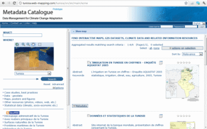
Metadata Catalogue for Climate Data in Tunisia
The International Climate Initiative of the German Federal Ministry for the Environment, Nature Conservation and Nuclear Safety (BMU) has commissioned the Deutsche Gesellschaft für Internationale Zusammenarbeit (GIZ) to develop an inventory of methods and tools for identifying and analyzing climate change impacts and prioritizing adaptation needs and measures in cooperation with international partners.
Client / Project Partners
GIZ GmbH
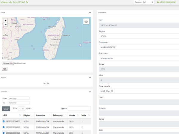
PLAE IV, Madagascar - GIS-based identification of intervention zones and impact monitoring of reforestation and erosion safety measures
geoSYS engaged in the development of a forest and risk management system. A smartphone application and a dashboard were developed to let users record, edit and upload spatial and attribute data, as well as visualize existing data. The smartphone application functions offline and data is locally stored in a SQLite / SpatiaLite database that synchronizes with a server-side PostgreSQL / PostGIS database once internet connection is obtained. Once uploaded the data can be visualized, filtered and queries in an online dashboard.
The GIS and analysis part of the project includes remote sensing analysis and classification of selected areas, by paying special attention to forest cover (extensive deforestation) and the directly linked erosion.
The possibilities of data collection, supported by the GIS and remote sensing analyses, make up a powerful monitoring system to identify risks and danger for local populations and natural areas as well as to support reforestation planning. Different groups of users of the mobile application and the dashboard were trained in Antananarivo and surrounding regions, introducing them to real-world scenarios and demonstrating offline functionality and multi-language support.
Client / Project Partners
GFA Consulting Group GmbH, KfW

Interoperable Spatial Data Infrastructures for Disaster Risk Management
The countries of Tajikistan and Kyrgyzstan are affected by climate change, which results in processes that overwhelm current systems and approaches. To tackle this, local spatial data infrastructures have been established to facilitate national and cross-border exchange of climate and disaster-related spatial data. However, there is a lack of knowledge on how to integrate available data by various government agencies and how to use tools to make quick decisions for short-term and long-term planning and disaster management.
geoSYS was commissioned by the GIZ to provide professional support in data processing, data extraction and migration of data to the spatial data infrastructures, in addition to developing analysis algorithms.
geoSYS provided an end-to-end blueprint for data processing workflows, from source datasets including numerical climate model outputs, earth observations and satellite images, digital elevation data as well as infrastructure data for road and railways, to value-added products based on internationally adopted standards.
Client / Project Partners
GIZ, Governments of Tajikistan, Kyrgyzstan
Management of natural resources and safeguarding of ecosystem services for sustainable rural development in the South Caucasus, Azerbaijan
The programme Management of natural resources and safeguarding of ecosystem services for sustainable rural development in the South Caucasus (ECOserve) is part of the wider German support in the priority area Environmental policy, conservation and sustainable use of natural resources in the South Caucasus, which aims at the sustainable use of natural resources, biodiversity conservation and climate protection, particularly for the benefit of the rural population, and at increasing the share of renewable energies in the energy mix and enhancing energy efficiency.
The objective of ECOserve is to improve the pre-conditions for the sustainable and biodiversity-friendly use of natural resources in the prevailing land-use systems in the South Caucasus, with a special focus on energy security for the rural population.
geoSYS has generated and provided geodata on various subject areas, collected basic data and, with the integration of remote sensing methods, made a significant contribution to the rapid evaluation of scenarios for agriculture and other sectors. The methods and tools used were passed on to the ministries involved in various training courses. The generated geodatabase is then automatically filled with new data. The availability of data as a basis for decision-making for the sustainable, biodiversity-friendly management of natural resources was improved.
Client / Project Partners
GIZ Azerbaijan, Ministry of Agriculture, Azerbaijan